Directions to Ladonia (by Car and by Foot)
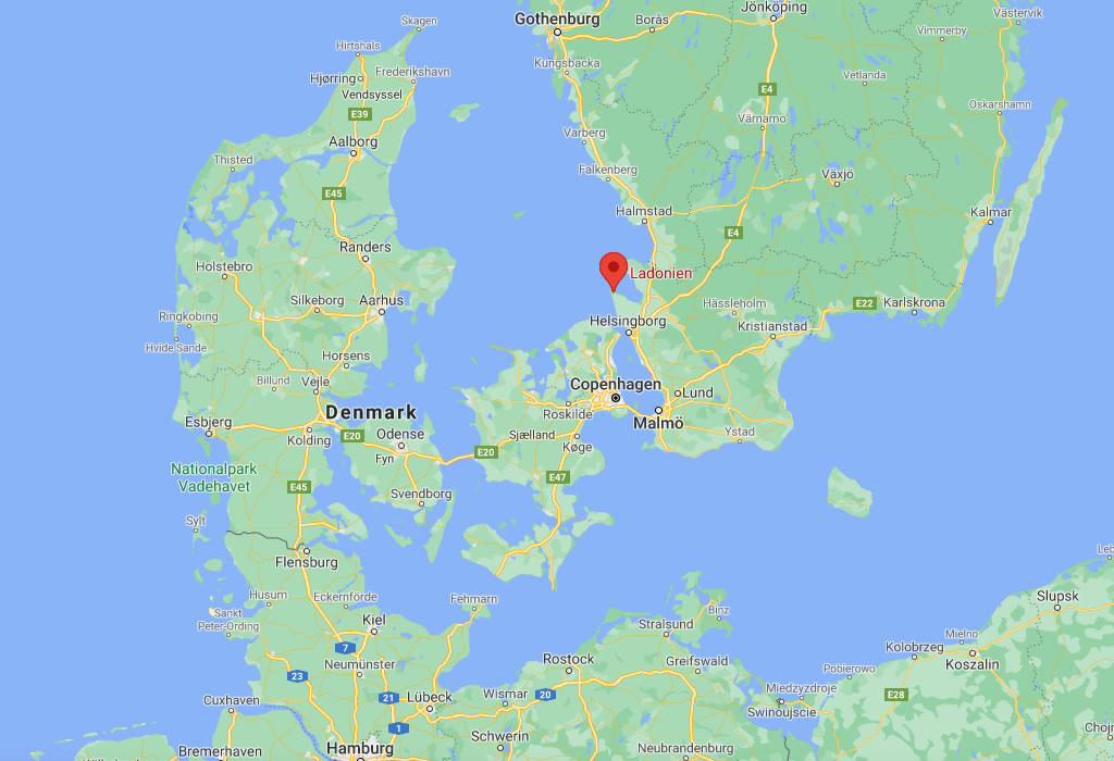
Ladonia is situated on the very southern edge of the Scandinavian Peninsula, somewhat between the Swedish towns of Mölle and Arild. The map coordinates of Ladonia are 56° 17′ 15″ N, 12° 32′ 22″ E. (Click and use it to plan your route). On many Google Maps, Ladonia is marked simply as “Nimis” or “Ladonien”.

Drive about 40 km northwest from Helsingborg. E20, E6, exit direction Höganäs (roads 112 or 111). Then follow the 111 to Mölle.
On the 111, just before the camping (on the left), you will arrive at a crossroad (200m from the camping). There, make a right to Arild and drive about 500m. Then, make a left on the Himmelstorpsvägen, which goes directly into the forest.
You will come to a clearing containing an old red barn. This is Himmelstorp. At Himmelstorp, you will find parking and signs to go to Nimis. Follow the signs (sometimes they are just yellow Ns carved into fence posts).
The walk is about 40 minutes long and is quite steep in some places and extremely uneven terrain.
The path begins as an easy stroll past Himmelstorp, a well-preserved eighteenth-century farmstead, but quickly becomes a steep and rocky climb down to the coast. Please wear good hiking shoes, and remember that getting *down* to Nimis is the easy part. Getting back up and out is a different story.
Wear sensible shoes, take enough water and food with you. And help others in need.
The Ladonian Landscape
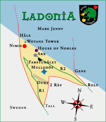
Ladonia is a triangle of land about 1 square km in size. Most visitors enter from the south and thus passing the Borderstation Tall. Highway No 1 leads to Nimis through woods and the steep precipice Stup.
Nimis
The total length of Nimis is about 200 meters and the highest point is about 15 meters. Every part of this wood-piece is possible to enter and you can walk inside it.
Nimis is in the heart of Ladonia, and lies a few kilometres northwest of the town of Arild and somewhat farther from the town of Mölle. It can only be reached on foot following a well-worn path with yellow “N”s painted on trees and fences.
Tower of Wotan – Tower of Winds
In front of Nimis you’ll find the Tower of Wotan which is situated close to the sea. Under the high Tower of the Winds the National Library is to be found.
Arx

About 60-70 meters to the east Arx appears. Arx is a stone-book of 150 tons. At the moment the second copy is almost finished thus forming together a small library consisting of 300 tons of stones and concrete.
Behind Arx there is a small opening between the bushes. Among the trees the Highway No 2 begins. After a few meters, the apple tree of the Hesperides can be found and shortly forward opens the ravine Farstuhålet with a small cave. Traces of human beings have been discovered here, probably very old.
After passing Farstuhålet the Wall (Kallmur) can be seen. It isn´t known who actually built it or when.
Highway No 2 leads to Drommen, a plain with trees and stones and brings the visitor to the east border and Borderstation Rolf with Rolf’s Park. These places are a memorial of the tragic death of the Swedish philosopher Rolf Gottfries.
While You’re in Ladonia...
See if you can find:
- The “Nelson” plaque that marks the final resting place of the baby white rhino, Nelson, who was born in a Swedish zoo in the 90s, but only lived about a week and a half. His ashes were brought to Ladonia to be buried.
- The Ladonian Pear Tree… it really bears fruit!
- The Ladonian Library
- The Seal Bones… they might still be there. The seal washed ashore in the summer of 2014 (and it was fairly unpleasant for awhile there, but he/she was too big to move back out to the ocean). Eventually, the poor seal was reduced to bones by time and weather. The Ladonian Ministry of Health has assured us that the seal did not die of ebola.